|
| at: |
Sam Houston National Forest |
Data from USFS GIS
 show on map
 animate
Trail users:


Elevation Profile
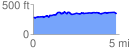
 4.809533 mi
 339.75 ft
 262.90 ft
 76.86 ft
 1.34 %
GPX Downloads: Track Route
![]()
|
| at: |
Sam Houston National Forest |
show on map
animate
4.809533 mi
339.75 ft
262.90 ft
76.86 ft
1.34 %