|
| at: |
Sam Houston National Forest |
Data from USFS GIS
 show on map
 animate
Trail users:


Elevation Profile
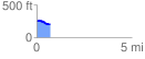
 0.746804 mi
 11.22 ft
 62.89 ft
 -51.67 ft
 1.59 %
GPX Downloads: Track Route
![]()
|
| at: |
Sam Houston National Forest |
show on map
animate
0.746804 mi
11.22 ft
62.89 ft
-51.67 ft
1.59 %