|
| at: |
Sam Houston National Forest |
Data from USFS GIS
 show on map
 animate
Trail users:


Elevation Profile
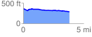
 3.861238 mi
 80.02 ft
 156.31 ft
 -76.29 ft
 0.77 %
GPX Downloads: Track Route
![]()
|
| at: |
Sam Houston National Forest |
show on map
animate
3.861238 mi
80.02 ft
156.31 ft
-76.29 ft
0.77 %