|
| at: |
Sam Houston National Forest |
Data from USFS GIS
 show on map
 animate
Trail users:


Elevation Profile
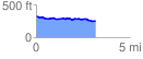
 3.246862 mi
 97.91 ft
 184.84 ft
 -86.93 ft
 1.08 %
GPX Downloads: Track Route
![]()
|
| at: |
Sam Houston National Forest |
show on map
animate
3.246862 mi
97.91 ft
184.84 ft
-86.93 ft
1.08 %