|
| at: |
Sam Houston National Forest |
Data from USFS GIS
 show on map
 animate
Trail users:


Elevation Profile
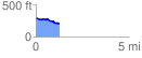
 1.261482 mi
 32.26 ft
 105.43 ft
 -73.17 ft
 1.58 %
GPX Downloads: Track Route
![]()
|
| at: |
Sam Houston National Forest |
show on map
animate
1.261482 mi
32.26 ft
105.43 ft
-73.17 ft
1.58 %