|
| at: |
Sam Houston National Forest |
Data from USFS GIS
 show on map
 animate
Trail users:


Elevation Profile
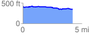
 4.230237 mi
 98.09 ft
 156.63 ft
 -58.54 ft
 0.70 %
GPX Downloads: Track Route
![]()
|
| at: |
Sam Houston National Forest |
show on map
animate
4.230237 mi
98.09 ft
156.63 ft
-58.54 ft
0.70 %