|
| at: |
Sam Houston National Forest |
Data from USFS GIS
 show on map
 animate
Trail users:


Elevation Profile
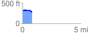
 0.816586 mi
 19.92 ft
 62.81 ft
 -42.88 ft
 1.46 %
GPX Downloads: Track Route
![]()
|
| at: |
Sam Houston National Forest |
show on map
animate
0.816586 mi
19.92 ft
62.81 ft
-42.88 ft
1.46 %