|
| at: |
Sam Houston National Forest |
Data from USFS GIS
 show on map
 animate
Trail users:


Elevation Profile
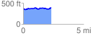
 2.325686 mi
 117.27 ft
 90.95 ft
 26.32 ft
 0.95 %
GPX Downloads: Track Route
![]()
|
| at: |
Sam Houston National Forest |
show on map
animate
2.325686 mi
117.27 ft
90.95 ft
26.32 ft
0.95 %