|
| at: |
Sam Houston National Forest |
Data from USFS GIS
 show on map
 animate
Trail users:


Elevation Profile
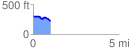
 1.007147 mi
 41.29 ft
 113.65 ft
 -72.36 ft
 2.14 %
GPX Downloads: Track Route
![]()
|
| at: |
Sam Houston National Forest |
show on map
animate
1.007147 mi
41.29 ft
113.65 ft
-72.36 ft
2.14 %