| at: |
Sam Houston National Forest |
Data from USFS GIS
 show on map
 animate
Trail users:


Elevation Profile
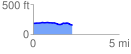
 2.298733 mi
 54.64 ft
 77.04 ft
 -22.40 ft
 0.63 %
GPX Downloads: Track Route
![]()
| at: |
Sam Houston National Forest |
show on map
animate
2.298733 mi
54.64 ft
77.04 ft
-22.40 ft
0.63 %