|
| at: |
Sam Houston National Forest |
Data from USFS GIS
 show on map
 animate
Trail users:


Elevation Profile
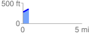
 0.500290 mi
 70.82 ft
 2.05 ft
 68.77 ft
 2.68 %
GPX Downloads: Track Route
![]()
|
| at: |
Sam Houston National Forest |
show on map
animate
0.500290 mi
70.82 ft
2.05 ft
68.77 ft
2.68 %