|
| at: |
Sam Houston National Forest |
Data from USFS GIS
 show on map
 animate
Trail users:


Elevation Profile
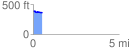
 0.549379 mi
 16.13 ft
 35.55 ft
 -19.43 ft
 1.23 %
GPX Downloads: Track Route
![]()
|
| at: |
Sam Houston National Forest |
show on map
animate
0.549379 mi
16.13 ft
35.55 ft
-19.43 ft
1.23 %