|
| at: |
Sam Houston National Forest |
Data from USFS GIS
 show on map
 animate
Trail users:


Elevation Profile
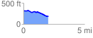
 2.048790 mi
 57.25 ft
 184.13 ft
 -126.88 ft
 1.70 %
GPX Downloads: Track Route
![]()
|
| at: |
Sam Houston National Forest |
show on map
animate
2.048790 mi
57.25 ft
184.13 ft
-126.88 ft
1.70 %