|
| at: |
Sam Houston National Forest |
Data from USFS GIS
 show on map
 animate
Trail users:


Elevation Profile
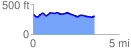
 3.612139 mi
 217.74 ft
 236.94 ft
 -19.20 ft
 1.24 %
GPX Downloads: Track Route
![]()
|
| at: |
Sam Houston National Forest |
show on map
animate
3.612139 mi
217.74 ft
236.94 ft
-19.20 ft
1.24 %