|
| at: |
Sam Houston National Forest |
Data from USFS GIS
 show on map
 animate
Trail users:


Elevation Profile
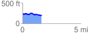
 1.646209 mi
 66.25 ft
 116.63 ft
 -50.38 ft
 1.34 %
GPX Downloads: Track Route
![]()
|
| at: |
Sam Houston National Forest |
show on map
animate
1.646209 mi
66.25 ft
116.63 ft
-50.38 ft
1.34 %