| at: |
Sam Houston National Forest |
Data from USFS GIS
 show on map
 animate
Trail users:


Elevation Profile
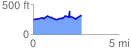
 2.874706 mi
 322.64 ft
 249.33 ft
 73.31 ft
 2.13 %
GPX Downloads: Track Route
![]()
| at: |
Sam Houston National Forest |
show on map
animate
2.874706 mi
322.64 ft
249.33 ft
73.31 ft
2.13 %