| at: |
Sam Houston National Forest |
Data from USFS GIS
 show on map
 animate
Trail users:


Elevation Profile
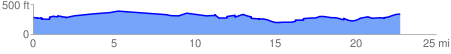
 22.974525 mi
 1041.50 ft
 1008.73 ft
 32.77 ft
 0.86 %
GPX Downloads: Track Route
![]()
| at: |
Sam Houston National Forest |
show on map
animate
22.974525 mi
1041.50 ft
1008.73 ft
32.77 ft
0.86 %