| at: |
Sam Houston National Forest |
Data from USFS GIS
 show on map
 animate
Trail users:


Elevation Profile
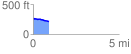
 0.904949 mi
 4.93 ft
 53.72 ft
 -48.80 ft
 1.12 %
GPX Downloads: Track Route
![]()
| at: |
Sam Houston National Forest |
show on map
animate
0.904949 mi
4.93 ft
53.72 ft
-48.80 ft
1.12 %