| at: |
Sam Houston National Forest |
Data from USFS GIS
 show on map
 animate
Trail users:


Elevation Profile
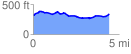
 4.490273 mi
 242.25 ft
 222.78 ft
 19.47 ft
 1.02 %
GPX Downloads: Track Route
![]()
| at: |
Sam Houston National Forest |
show on map
animate
4.490273 mi
242.25 ft
222.78 ft
19.47 ft
1.02 %