| at: |
Sam Houston National Forest |
Data from USFS GIS
 show on map
 animate
Trail users:


Elevation Profile
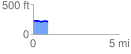
 0.853810 mi
 18.19 ft
 33.69 ft
 -15.51 ft
 0.75 %
GPX Downloads: Track Route
![]()
| at: |
Sam Houston National Forest |
show on map
animate
0.853810 mi
18.19 ft
33.69 ft
-15.51 ft
0.75 %