| at: |
Sam Houston National Forest |
Data from USFS GIS
 show on map
 animate
Trail users:


Elevation Profile
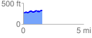
 1.823708 mi
 147.92 ft
 128.83 ft
 19.09 ft
 1.54 %
GPX Downloads: Track Route
![]()
| at: |
Sam Houston National Forest |
show on map
animate
1.823708 mi
147.92 ft
128.83 ft
19.09 ft
1.54 %