| at: |
Sam Houston National Forest |
Data from USFS GIS
 show on map
 animate
Trail users:


Elevation Profile
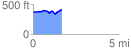
 1.693440 mi
 140.83 ft
 95.87 ft
 44.96 ft
 1.58 %
GPX Downloads: Track Route
![]()
| at: |
Sam Houston National Forest |
show on map
animate
1.693440 mi
140.83 ft
95.87 ft
44.96 ft
1.58 %