| at: |
Sam Houston National Forest |
Data from USFS GIS
 show on map
 animate
Trail users:


Elevation Profile
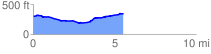
 5.578093 mi
 242.14 ft
 193.41 ft
 48.72 ft
 0.82 %
GPX Downloads: Track Route
![]()
| at: |
Sam Houston National Forest |
show on map
animate
5.578093 mi
242.14 ft
193.41 ft
48.72 ft
0.82 %