| at: |
Sam Houston National Forest |
Data from USFS GIS
 show on map
 animate
Trail users:


Elevation Profile
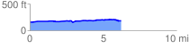
 6.231967 mi
 156.90 ft
 130.99 ft
 25.92 ft
 0.48 %
GPX Downloads: Track Route
![]()
| at: |
Sam Houston National Forest |
show on map
animate
6.231967 mi
156.90 ft
130.99 ft
25.92 ft
0.48 %