| at: |
Sam Houston National Forest |
Data from USFS GIS
 show on map
 animate
Trail users:


Elevation Profile
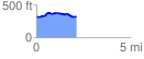
 2.181850 mi
 106.71 ft
 114.66 ft
 -7.95 ft
 1.00 %
GPX Downloads: Track Route
![]()
| at: |
Sam Houston National Forest |
show on map
animate
2.181850 mi
106.71 ft
114.66 ft
-7.95 ft
1.00 %