| at: |
Sam Houston National Forest |
Data from USFS GIS
 show on map
 animate
Trail users:


Elevation Profile
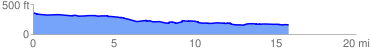
 16.062352 mi
 263.86 ft
 466.43 ft
 -202.57 ft
 0.55 %
GPX Downloads: Track Route
![]()
| at: |
Sam Houston National Forest |
show on map
animate
16.062352 mi
263.86 ft
466.43 ft
-202.57 ft
0.55 %