| at: |
Sam Houston National Forest |
Data from USFS GIS
 show on map
 animate
Trail users:


Elevation Profile
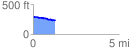
 1.303425 mi
 30.10 ft
 106.62 ft
 -76.51 ft
 1.55 %
GPX Downloads: Track Route
![]()
| at: |
Sam Houston National Forest |
show on map
animate
1.303425 mi
30.10 ft
106.62 ft
-76.51 ft
1.55 %