| at: |
Sam Houston National Forest |
Data from USFS GIS
 show on map
 animate
Trail users:


Elevation Profile
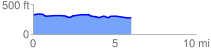
 6.041105 mi
 125.28 ft
 174.52 ft
 -49.24 ft
 0.55 %
GPX Downloads: Track Route
![]()
| at: |
Sam Houston National Forest |
show on map
animate
6.041105 mi
125.28 ft
174.52 ft
-49.24 ft
0.55 %