| at: |
Sam Houston National Forest |
Data from USFS GIS
 show on map
 animate
Trail users:


Elevation Profile
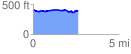
 2.615004 mi
 127.71 ft
 148.50 ft
 -20.79 ft
 1.08 %
GPX Downloads: Track Route
![]()
| at: |
Sam Houston National Forest |
show on map
animate
2.615004 mi
127.71 ft
148.50 ft
-20.79 ft
1.08 %