| at: |
Sam Houston National Forest |
Data from USFS GIS
 show on map
 animate
Trail users:


Elevation Profile
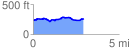
 2.956467 mi
 173.18 ft
 164.22 ft
 8.96 ft
 1.11 %
GPX Downloads: Track Route
![]()
| at: |
Sam Houston National Forest |
show on map
animate
2.956467 mi
173.18 ft
164.22 ft
8.96 ft
1.11 %