| at: |
Sam Houston National Forest |
Data from USFS GIS
 show on map
 animate
Trail users:


Elevation Profile
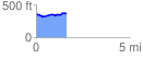
 1.631309 mi
 78.35 ft
 71.73 ft
 6.62 ft
 0.91 %
GPX Downloads: Track Route
![]()
| at: |
Sam Houston National Forest |
show on map
animate
1.631309 mi
78.35 ft
71.73 ft
6.62 ft
0.91 %