| at: |
Sam Houston National Forest |
Data from USFS GIS
 show on map
 animate
Trail users:


Elevation Profile
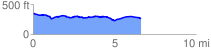
 6.693352 mi
 249.63 ft
 352.18 ft
 -102.55 ft
 1.00 %
GPX Downloads: Track Route
![]()
| at: |
Sam Houston National Forest |
show on map
animate
6.693352 mi
249.63 ft
352.18 ft
-102.55 ft
1.00 %