| at: |
Sam Houston National Forest |
Data from USFS GIS
 show on map
 animate
Trail users:


Elevation Profile
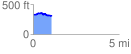
 1.081996 mi
 56.74 ft
 82.04 ft
 -25.29 ft
 1.44 %
GPX Downloads: Track Route
![]()
| at: |
Sam Houston National Forest |
show on map
animate
1.081996 mi
56.74 ft
82.04 ft
-25.29 ft
1.44 %