| at: |
Sam Houston National Forest |
Data from USFS GIS
 show on map
 animate
Trail users:


Elevation Profile
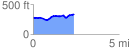
 2.414209 mi
 211.39 ft
 154.28 ft
 57.11 ft
 1.66 %
GPX Downloads: Track Route
![]()
| at: |
Sam Houston National Forest |
show on map
animate
2.414209 mi
211.39 ft
154.28 ft
57.11 ft
1.66 %