| at: |
Sam Houston National Forest |
Data from USFS GIS
 show on map
 animate
Trail users:


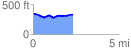
Elevation Profile
 2.386996 mi
 183.41 ft
 195.52 ft
 -12.11 ft
 1.55 %
GPX Downloads: Track Route
![]()
| at: |
Sam Houston National Forest |
show on map
animate
2.386996 mi
183.41 ft
195.52 ft
-12.11 ft
1.55 %