| at: |
Sam Houston National Forest |
Data from USFS GIS
 show on map
 animate
Trail users:


Elevation Profile
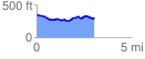
 3.099991 mi
 194.61 ft
 241.66 ft
 -47.05 ft
 1.48 %
GPX Downloads: Track Route
![]()
| at: |
Sam Houston National Forest |
show on map
animate
3.099991 mi
194.61 ft
241.66 ft
-47.05 ft
1.48 %