| at: |
Sam Houston National Forest |
Data from USFS GIS
 show on map
 animate
Trail users:

Elevation Profile
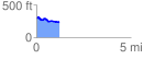
 1.250217 mi
 69.67 ft
 122.32 ft
 -52.65 ft
 1.85 %
GPX Downloads: Track Route
![]()
| at: |
Sam Houston National Forest |
show on map
animate
1.250217 mi
69.67 ft
122.32 ft
-52.65 ft
1.85 %