| at: |
Sam Houston National Forest |
Data from USFS GIS
 show on map
 animate
Trail users:

Elevation Profile
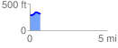
 0.706562 mi
 74.15 ft
 66.09 ft
 8.06 ft
 1.99 %
GPX Downloads: Track Route
![]()
| at: |
Sam Houston National Forest |
show on map
animate
0.706562 mi
74.15 ft
66.09 ft
8.06 ft
1.99 %