| at: |
West Georgia Pinhoti Trans North Georgia Johns Mountain WMA |
Data from David Muse
 show on map
 animate
Trail users:


Elevation Profile
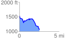
 2.508257 mi
 187.56 ft
 668.77 ft
 -481.21 ft
 5.05 %
GPX Downloads: Track Route
![]()
| at: |
West Georgia Pinhoti Trans North Georgia Johns Mountain WMA |
show on map
animate
2.508257 mi
187.56 ft
668.77 ft
-481.21 ft
5.05 %