| at: |
West Georgia Pinhoti Trans North Georgia Johns Mountain WMA |
Data from David Muse
 show on map
 animate
Trail users:


Elevation Profile
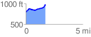
 1.723256 mi
 221.85 ft
 55.25 ft
 166.60 ft
 2.44 %
GPX Downloads: Track Route
![]()
| at: |
West Georgia Pinhoti Trans North Georgia Johns Mountain WMA |
show on map
animate
1.723256 mi
221.85 ft
55.25 ft
166.60 ft
2.44 %