| at: |
West Georgia Pinhoti Johns Mountain WMA |
Data from USFS GIS
 show on map
 animate
Trail users:


Elevation Profile
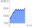
 4.009083 mi
 1133.48 ft
 430.00 ft
 703.48 ft
 5.35 %
GPX Downloads: Track Route
![]()
| at: |
West Georgia Pinhoti Johns Mountain WMA |
show on map
animate
4.009083 mi
1133.48 ft
430.00 ft
703.48 ft
5.35 %