| at: |
Camp Wahsega |
Data from David Muse
 show on map
 animate
Trail users:

Elevation Profile
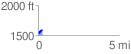
 0.262946 mi
 56.41 ft
 2.47 ft
 53.94 ft
 4.06 %
GPX Downloads: Track Route
![]()
| at: |
Camp Wahsega |
show on map
animate
0.262946 mi
56.41 ft
2.47 ft
53.94 ft
4.06 %