|
| at: |
Coopers Creek WMA |
Data from David Muse
 show on map
 animate
Trail users:


Elevation Profile
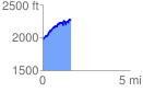
 1.622930 mi
 470.60 ft
 183.44 ft
 287.16 ft
 5.49 %
GPX Downloads: Track Route
![]()
|
| at: |
Coopers Creek WMA |
show on map
animate
1.622930 mi
470.60 ft
183.44 ft
287.16 ft
5.49 %