|
| at: |
Windy Gap Mulberry Gap |
Data from David Muse
 show on map
 animate
Trail users:


Elevation Profile
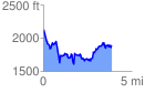
 3.908897 mi
 1336.48 ft
 1557.13 ft
 -220.65 ft
 7.54 %
GPX Downloads: Track Route
![]()
|
| at: |
Windy Gap Mulberry Gap |
show on map
animate
3.908897 mi
1336.48 ft
1557.13 ft
-220.65 ft
7.54 %