|
| at: |
Rich Mountain |
Data from David Muse
 show on map
 animate
Trail users:


Elevation Profile
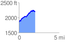
 2.006391 mi
 537.80 ft
 205.22 ft
 332.58 ft
 5.08 %
GPX Downloads: Track Route
![]()
|
| at: |
Rich Mountain |
show on map
animate
2.006391 mi
537.80 ft
205.22 ft
332.58 ft
5.08 %