| at: |
West Georgia Pinhoti Johns Mountain WMA |
Data from David Muse
 show on map
 animate
Trail users:


Elevation Profile
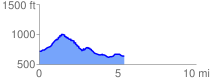
 5.416177 mi
 432.58 ft
 503.50 ft
 -70.92 ft
 1.76 %
GPX Downloads: Track Route
![]()
| at: |
West Georgia Pinhoti Johns Mountain WMA |
show on map
animate
5.416177 mi
432.58 ft
503.50 ft
-70.92 ft
1.76 %