| at: |
Clayton County International Park |
Data from David Muse
 show on map
 animate
Trail users:


Elevation Profile
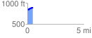
 0.487829 mi
 93.28 ft
 54.58 ft
 38.69 ft
 3.62 %
GPX Downloads: Track Route
![]()
| at: |
Clayton County International Park |
show on map
animate
0.487829 mi
93.28 ft
54.58 ft
38.69 ft
3.62 %