| at: |
Clayton County International Park |
Data from David Muse
 show on map
 animate
Trail users:

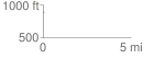
Elevation Profile
 0.047654 mi
 11.95 ft
 0.08 ft
 11.87 ft
 4.75 %
GPX Downloads: Track Route
![]()
| at: |
Clayton County International Park |
show on map
animate
0.047654 mi
11.95 ft
0.08 ft
11.87 ft
4.75 %