| at: |
Rocky Hill Ranch |
Data from Jason Sager
 show on map
 animate
Trail users:


Elevation Profile
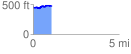
 1.084986 mi
 96.07 ft
 65.23 ft
 30.84 ft
 1.68 %
GPX Downloads: Track Route
![]()
| at: |
Rocky Hill Ranch |
show on map
animate
1.084986 mi
96.07 ft
65.23 ft
30.84 ft
1.68 %