| at: |
Sumter National Forest - Long Cane District |
Data from USFS GIS
 show on map
 animate
Trail users:


Elevation Profile
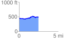
 2.532316 mi
 144.75 ft
 98.46 ft
 46.29 ft
 1.08 %
GPX Downloads: Track Route
![]()
| at: |
Sumter National Forest - Long Cane District |
show on map
animate
2.532316 mi
144.75 ft
98.46 ft
46.29 ft
1.08 %